
McGillivray Boulevard Safety and Mobility Project
Project Overview
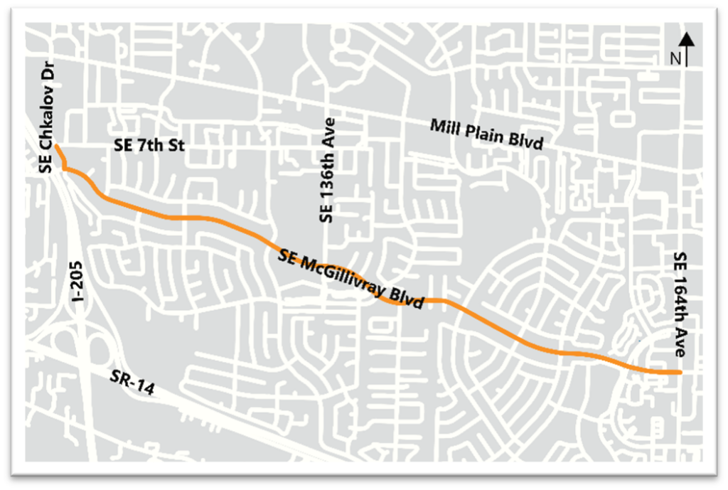
The Project evaluated potential changes to improve safety and mobility for all who travel on SE McGillivray Boulevard between SE Chkalov Drive and SE 164th Avenue. Striping changes and mobility improvements are scheduled to be done in coordination with planned pavement work.
McGillivray Boulevard is part of the major east-west corridor of the City’s transportation network, connecting SE 34th Street, McArthur Blvd, and McLoughlin Blvd.
Where are we now?
We are currently in the Design Phase. Construction is expected to occur with the planned pavement work in 2025 and 2026.
Background
The Project began in Fall 2022 and the planning phase concluded in Spring 2024.
Phase 1 Analyze the Corridor: The project team evaluated how McGillivray Boulevard operates and how people travel on the corridor today. Input was collected to understand where people want to use the corridor to travel, how they want to travel and barriers to traveling to key destinations.
Phase 2 Develop Options: The project team used information gathered during the Phase 1 to develop project goals and evaluation framework, preliminary and draft design options, and evaluation of how the design options met the project goals. Feedback was sought in community conversations and online on how well the design options addressed the needs and desires for traveling identified in Phase 1.
Phase 3 Design Improvements: The project team used information gathered, including community input from Phase 1 and Phase 2, traffic analysis, and best practices in design and policy, to recommend a final design option. The final design and implementation milestones will be shared with community members and key stakeholders.
Project Goals
The Project had three goals, developed from community and Transportation and Mobility Commission input gathered in Phase 1.
Goal #1 Lower Vehicle Speeds
Lower vehicle travel speeds on the corridor to improve safety for all users regardless of how they travel and to reduce cut-through traffic to support the local road context.
Goal #2 Improve Safety and Comfort
Make the corridor safe and comfortable for people of all ages and abilities to walk, bike, roll, use small mobility devices, and access transit.
Goal #3 Improve Intersections and Crossings
Improve safety and comfort at intersections and crossings on the corridor.
Community Engagement
Engagement activities and key takeaways from Phase 1 and Phase 2 are in the tables below. Phase 3 of community engagement included sharing the final design option and expected implementation timeline.
Engagement Activities
| Phase 1 Analyze the Corridor | Phase 2 Develop Design Options |
|---|---|
| Walk and Bike Audits | Community Conversations (small focus group meetings) |
| Online Community and School Surveys and Interactive Map | Online Community Survey |
| In-person Open House | Tabling at Community Events |
| Presentations to Neighborhood Associations | Presentations to Neighborhood Associations |
Key Takeaways
| Phase 1 Analyze the Corridor | Phase 2 Develop Design Options |
|---|---|
| Vehicle speeding is impacting all users. | Preference for enhanced separation between mobility land and vehicle lane. |
| Intersections are confusing and improvements are needed. | Preference for separation of space for people walking and riding bicycles. |
| Some people walk, bike, and roll today, but it’s not comfortable for everyone. | Support for more space for people walking, riding bicycles and small mobility devices. |
| Concern about driver education required for new roadway configuration. |
Design
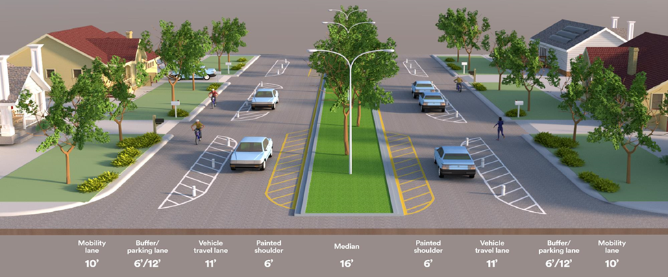
With input from the community and an evaluation of proposed design options, a curbside mobility lane was recommended by the Transportation and Mobility Commission to the City. This design will repurpose a travel lane in each direction on McGillivray Boulevard to provide separated and protected mobility lanes, as well as install vertical separators, high visibility mid-block crossing and crosswalks, modular bus platforms, and restripe parking to increase safety benefits. This design will also include the use of green paint to indicate where people biking and using small mobility devices should wait and cross at intersections and an addition of a Rectangular Rapid Flashing Beacon (RRFB) at the existing mid-block crossing.
Longer Term Recommendation
The project team recommended longer-term improvements that fall outside the scope and timeline of this Project but have been identified for inclusion in the Transportation Improvement Plan. This includes potential changes to intersection controls (a traffic signal or roundabout) at the SE 136th Avenue and SE Village Loop Drive intersections if vehicle traffic increases in line with 10- and 20-year forecasts.
Construction
Construction is expected to occur with the planned pavement work in 2025 and 2026.
Evaluation
All Complete Streets projects have an embedded post project evaluation to determine how the added safety and mobility elements function, and to recommend refinements and changes if needed. This is the final stage of a Complete Streets project after which the road is monitored for safety or other issues in the same manner as all city streets.
Files
 Questions and Answers
Existing Conditions – Traffic Analysis Report June 2023
Existing Conditions – Traffic Analysis Report Appendices: A Traffic Counts, B Level of Service Reports
Future Conditions
Community Engagement Phase 1 Summary (page 1 English, page 2 Spanish)
Community Engagement Phase 2 Summary 9/13/2023
Community Engagement Phase 2 Summary 1/12/2024
Community Engagement Phase 3 Fact Sheet
Questions and Answers
Existing Conditions – Traffic Analysis Report June 2023
Existing Conditions – Traffic Analysis Report Appendices: A Traffic Counts, B Level of Service Reports
Future Conditions
Community Engagement Phase 1 Summary (page 1 English, page 2 Spanish)
Community Engagement Phase 2 Summary 9/13/2023
Community Engagement Phase 2 Summary 1/12/2024
Community Engagement Phase 3 Fact Sheet
 Video – Curbside Mobility Lane