
29th and 33rd Streets Safety and Mobility Project
Overview
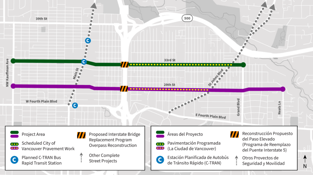
The 29th and 33rd Streets Safety and Mobility Project studied how to better meet the needs of people traveling along 29th Street (between Kauffman Avenue and Neals Lane) and 33rd Street (between Kauffman Avenue and Grand Boulevard).
Where are we now?
The recommended improvements between the I-5 overpasses and St. Johns Boulevard will be implemented in summer 2025 through planned pavement work. All other improvements will be implemented in the future as funding is secured.
Background
29th and 33rd Streets connect Vancouver neighborhoods separated by Interstate 5 (I-5), a major U.S. highway and freight route, and provide important connections to other roads, such as Main Street, St. Johns Boulevard and Grand Boulevard. This area boasts a mix of residential and commercial activity and is located within five Vancouver neighborhoods: Fourth Plain Village, Rose Village, Shumway, Carter Park and Lincoln. A complete summary of the current conditions along 29th and 33rd Streets can be found in the Existing Conditions Report.
The 2024-2044 Transportation System Plan, which guides how the City improves its streets so that it is safe for everyone to travel, informed the goals for the project, which include:
- Improve pedestrian safety and connectivity by adding/upgrading crossings, sidewalks, and curb ramps.
- Improve bike and small mobility safety and connectivity by addressing network gaps and connecting low-stress facilities.
- Improve the condition of the roadway through planned pavement work to ensure a smoother and safer travel experience for all road users.
- Ensure that all members of the community, regardless of race, income, or ability, have equal access to safe transportation options and infrastructure improvements.
Community Engagement
Milestone 1 (June – August 2024)
Purpose: Gather public input on existing safety and mobility issues along 29th and 33rd Streets.
Activities: Online comment form and interactive map on the project website, tabling sessions, small group briefings, canvassing to churches and businesses, email newsletters, social media, and yard signs placed throughout the project area.
Common themes: Speeding, lighting needs, accessibility issues and gaps in the active transportation network.
Milestone 2 (September – October 2024)
Purpose: Gather feedback on the proposed corridor improvements for 29th and 33rd Streets.
Activities: Online survey, mailer small group briefings, canvassing to churches, businesses and residents, email newsletters, social media, and yard signs placed throughout the project area.
Common themes: Community members felt that almost all the proposed improvements would make them feel safer or a lot safer but some people expressed concerns about the removal of on-street parking in their neighborhood.
A complete summary of community engagement for this project can be found in the Milestone 1 and Milestone 2 Engagement Summaries.
Design
Recommended improvements along 29th and 33rd Streets were developed based on existing City policy, the existing conditions analysis, community feedback and input from the Vancouver Transportation and Mobility Commission. A summary of existing conditions and recommended improvements are provided below.
29th Street
Existing Conditions: Speeding traffic, no shared lane markings for people biking or using small mobility devices, sidewalks missing or in poor condition, poor visibility at crossings, particularly at major intersections and parking on both sides of the street.
Recommended Improvements: Reduce the speed limit from 25 to 20 mph, install speed humps and traffic circles to slow down cars, install shared lane markings, upgrade curb ramps to meet accessibility standards and remove some on-street parking at intersections to improve visibility at crossings.
33rd Street
Existing Conditions: Speeding traffic, no bike or small mobility lanes west of N Street, inconsistent bicycle lanes at intersections with median islands, higher number of crashes at major intersections, and limited marked crossings.
Recommended Improvements: Reduce the speed limit from 30 to 25mph east of Main Street and 25 to 20 mph west of Main Street, remove some on-street parking to make room for consistent bike and small mobility lanes, remove median islands and replace with speed cushions and rectangular rapid flashing beacons and install new high visibility crossings.
For more details, view the Existing Conditions Report and Final Recommendations Report.
Construction
Construction is expected to occur over many years with multiple projects. In the near term, construction will occur in coordination with the planned pavement work in summer 2025. All other improvements will be implemented in the future as funding is secured. A complete summary of the funded and unfunded recommendations can be found in the 29th and 33rd Streets Safety and Mobility Final Report.
Contact
Maggie Derk, Senior Transportation Planner
maggie.derk@cityofvancouver.us
360-487-7889
