
St. Johns – St. James Safety and Mobility Project
Project Overview
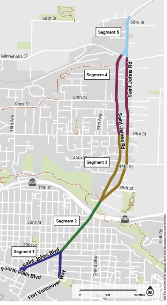
The St. Johns and St. James Safety and Mobility Project explored opportunities to create and implement safety and mobility improvements for all users on this critical north-south connection. The Project corridor is on NE St. Johns Boulevard/Road and NE St. James Road between Fourth Plain Boulevard and NE 68th Street.
Where are we now?
The Project completed the planning process and is moving into the design phase for the near-term recommendations.
Overview
The Project started in early 2024 by understanding how the streets function today, gathered input from the community to inform project goals and potential changes, and resulted in a corridor plan with conceptual designs in early 2025.
This is different than Complete Streets Projects in that a vehicle travel lane will not be removed and existing parking will remain, except at some locations near intersections and driveways to increase visibility and safety. Further, only part of the corridor is planned for near-term pavement work. So, design recommendations are planned to be implemented in three timeframes: near-term with planned pavement work, in the short-term and long-term.
Over time, the concept designs and recommended safety elements will be developed into final design plans, seek funding and be constructed.
Background
This corridor serves a critical north-south link connecting Clark County and the City and connecting to other major Complete Streets corridors (e.g. Fort Vancouver Way, Fourth Plain Boulevard, 29th Street, 33rd Street), SR 500 and regional trails.
The corridor is identified in the Transportation System Plan as both a pedestrian, bike and small mobility and transit modal networks. The City’s Local Road Safety Plan identified the NE St. Johns – NE St. James corridor as an area needing safety and accessibility improvements. It’s a high crash corridor that does not provide safe, comfortable or continuous facilities for people walking, biking, using a mobility device, accessing transit, as well as those driving.
The goals of the project are to advance the City’s central goals of equity, safety, and climate and improve safety for all modes, including for pedestrian, bicyclists and small mobility users, those accessing transit, as well as vehicle traffic.
Community Engagement
Community Engagement occurred in all phases with the goals to build community awareness and understanding of the project needs as well as enable well informed participating and share how input was used in decision making.
Phase 1
Understand the concerns and needs of community members, agencies and organizations impacted by the project.
Purpose
Activities
- Outreach to schools, neighborhood associations, business and faith institutions
- In-person evening open house on April 17, 2024, at Discovery Middle School
- Transportation and Mobility Commission Workshop
Feedback
- Most people use a car or truck.
- Major concern is speeding and aggressive driving.
- Safety is the top concern to address.
- Need for continuous and connected sidewalks and bike lanes and safe crossings.
Phase 2
Purpose
Share the draft concept design options and improvements and gather public and partner feedback to incorporate.
Activities
- Outreach to schools, neighborhood associations, business and faith institutions
- In-person tabling and canvassing at businesses and bus stops
- Transportation and Mobility Commission Workshop
Feedback
- Most people think the proposed improvements would significantly, somewhat or slightly improve safety.
- Highest safety improvement priorities are pedestrian crossings and traffic calming.
Phase 3
We shared how input from the community influenced the recommended design concepts to improve safety and the roadway using the same communication channels.
Design
The Concept Design Options Report serves as a corridor plan that outlines design concepts and recommendations by segment, based on existing conditions and expected timeline to complete. The Report is informed by the Project’s existing conditions work, community engagement, multiple workshops with internal partners and external partners and policy documents including the Complete Streets Policy, Transportation System Plan, Climate Action Framework and Strategic Plan.
Segments 1A and 1B
Existing Conditions
Vehicle speeding, poor visibility at intersections, and degraded crossings.
Proposed Improvements
Protected mobility lanes, narrowed travel lanes, improved crosswalks, luminary upgrades, and medians.
Segments 2
Existing Conditions
Poor visibility at intersections and degraded crossings.
Proposed Improvements
Protected mobility lanes, narrowed travel lanes, enhanced crossings with rectangular rapid flashing beacons, intersection reconfigurations and medians.
Segments 3 and 4
Existing Conditions
Vehicle speeding, lack of consistent and/or protected pedestrian and mobility facilities, degraded crossings.
Proposed Improvements
Protected mobility lanes, maintaining parking at inside curb lane, reduced curb radii, sidewalk infill, luminary upgrades, enhanced crossing with rectangular rapid flashing beacon, modular bus stop, and islands.
Segments 5
Existing Conditions
Vehicle speeding, lack of consistent pedestrian and mobility facilities, and degraded crossings.
Proposed Improvements
Protected mobility lanes, narrowed travel lanes, sidewalk infill, luminary upgrades, enhanced crossing with rectangular rapid flashing beacon, and medians.
Construction
Construction is expected to occur over many years with multiple projects. In the near term, construction will occur in coordination with the planned pavement preservation work in 2026. Recommendations for short- and long-term will occur as funding is available. See the list of recommendations and timeframes in the Corridor Plan – Concept Design Options Report.
Evaluation
All Complete Streets projects have an embedded post project evaluation to determine how the added safety and mobility elements function, and to recommend refinements and changes if needed. This is the final stage of Complete Streets projects and occurs in the year following the project’s construction. After the evaluation is complete, road is monitored for safety or other issues in the same manner as all city streets.
